Mount Pinatubo
Mount Pinatubo
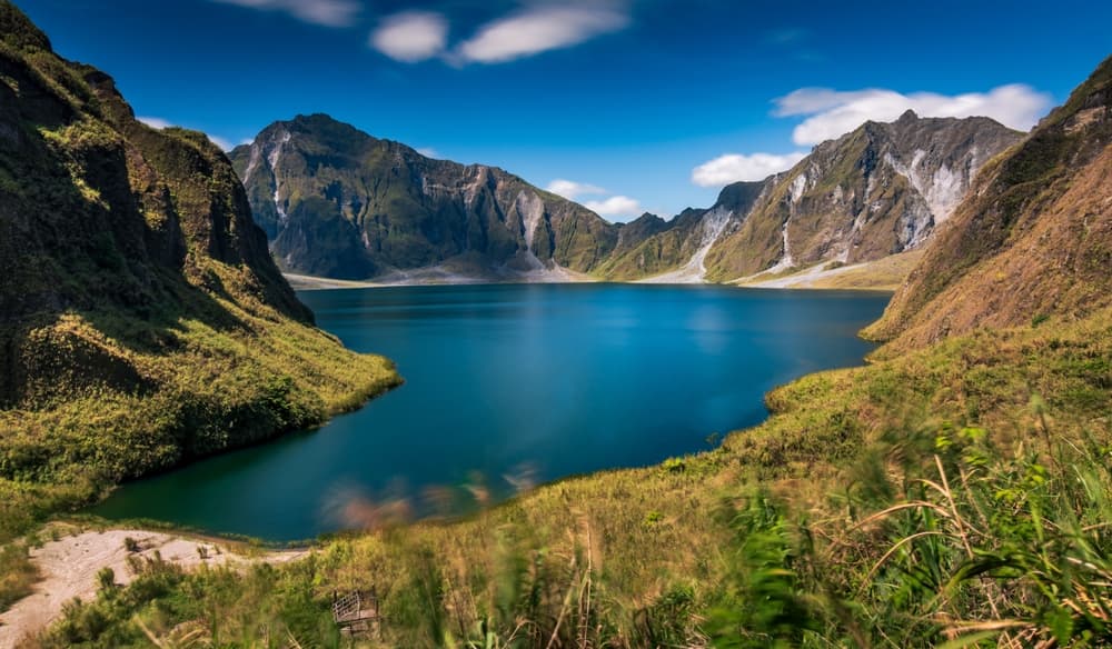
Mount Pinatubo, an active stratovolcano 90 km from Manila, harbors a crater lake with turquoise waters born from the 1991 eruption. A trek through striking volcanic landscapes, accessible during the dry season.
Mount Pinatubo is an active stratovolcano located at the border of Pampanga, Tarlac, and Zambales provinces, approximately 90 km northwest of Manila. Its eruption in June 1991 — one of the most powerful of the 20th century — carved a crater now filled with turquoise waters. This lunar landscape, surrounded by solidified ash and vegetation slowly reclaiming the terrain, draws trekkers and wilderness enthusiasts alike.
Quick Reference Guide
- Access: typical departure from Capas (Tarlac) or Santa Juliana; 4×4 ride followed by mandatory hiking.
- Recommended duration: full day (early morning departure recommended).
- Gear: waterproof hiking boots, lightweight but protective clothing, hat, sunscreen.
- Season: accessible mainly from November to May (dry season); monsoon rains make trails dangerous.
- Permit: a trekking permit is required; obtain it from local authorities at the departure point.
- Accessibility: not accessible — rough terrain, river crossings and mandatory hiking.
What You'll See
The crater lake is the highlight of the visit: its waters shift in hue depending on the light, from emerald green to milky blue, due to the mineral composition of the lakebed. Around the lake, the crater walls form an amphitheater of ash and volcanic rock. Along the route, lahars — solidified mudflows — have carved ravines and gray formations that contrast with the tropical vegetation slowly recolonizing the terrain.
History and Context
Pinatubo was considered an extinct volcano before 1991. Its sudden awakening on June 15, 1991, ejected ash 35 km into the atmosphere and cooled global temperatures by approximately 0.5°C for two years. Tens of thousands of residents, including the Aeta communities living on its slopes, were evacuated. The nearby American Clark Air Base was abandoned. Since then, nature has gradually reclaimed the area, and the Aeta have partially reinhabited the surroundings, often serving as local guides.
Highlights of the Visit
The 4×4 Journey Through the Lahars
Before reaching the hiking trail, the 4×4 route crosses lahar plains resembling a gray desert. Vehicles ford rivers and navigate formations eroded by successive rains. This passage is a striking visual experience in itself.
The Trek to the Crater
The trail from the usual starting point leads to the crater rim through progressively more mineral landscape. The final climb, across compacted ash, offers a sudden view of the lake below. Descent to the water's edge is possible depending on conditions.
The Crater Lake
At the lake's edge, geothermal heat can sometimes be felt. The water's color, the silhouette of the walls, and the site's silence create a rare atmosphere. Swimming has been permitted in the past but conditions vary; check with local authorities before venturing in.
Photography Tips
Morning light, before mist rises, is ideal for photographing the lake from the crater rim. Contrasts between gray ash and colored waters are sharper early in the day. A wide-angle lens captures the entire crater. Avoid midday hours when light is harsh and mist frequent.
Location and Access
The most common starting point is the barangay of Santa Juliana, in Capas (Tarlac). From Manila, reach Capas by bus or car (approximately 2 to 3 hours depending on traffic). Local agencies organize 4×4 excursions with guides from Angeles City or San Fernando (Pampanga). Angeles City is a convenient base for organizing the visit.
Nearby Areas
- Angeles City — vibrant city near the former Clark Base, frequent departure point for Pinatubo excursions.
- Clark Freeport Zone — former American air base converted into a tourism destination, featuring museums and tourist facilities.
- San Fernando (Pampanga) — provincial capital known for its craft traditions and local gastronomy.
Frequently asked questions
The dry season, from November to May, is the only practicable period. During the monsoon (June to October), lahar trails become dangerous and the site is often closed.
A local guide is mandatory and obtained at the departure point. Aeta guides know the terrain and daily conditions intimately. Solo trekking is strongly discouraged.
Swimming has been permitted intermittently depending on volcanic activity and local authority decisions. Check conditions with your guide or the local office before your visit.
The trek is moderate to demanding depending on the chosen route. Good physical fitness is recommended. The 4×4 ride precedes hiking, but the final climb across ash requires effort.
Angeles City and Clark Freeport Zone are easily visited the same day or the day before. San Fernando (Pampanga) is also accessible for a gastronomic or cultural stop.
No particular photography restrictions are noted on site. Plan for a spare battery: the day is long and photo opportunities abundant from the 4×4 ride onward.
Want to discover this destination?
Our local advisors design your tailor-made trip.